Monthly Archives: September 2013

Iguazu falls: Argentinean side

On the evening of the same day of visiting the Brazilian Iguaçu falls, I moved over the border to Argentina. A bus takes there, leaves you at the border to go through immigration, but issues a special ticket. With this ticket you board the next bus. The next morning I went to the National park on the Argentine side.

This is how the Devil’s Throat looks out of Argentina:

Continue reading Iguazu falls: Argentinean side

Iguaçu falls: Brazilian side

I took a morning bus from Asunción to Ciudad del Este, second largest city in Paraguay. The main attraction of that city is its function as a trade and contraband centre on the border with Brazil and Argentina. Its main streets are a giant market, full of visitors from the neighbouring countries trying to snatch cheap electronics and clothes. Apart from that couple of kilometres upriver there is a huge dam, which was in fact the largest in the world before the Three Gorges Dam in China was finalised. My objective however was the town of Foz do Iguaçu in Brazil, from which the Brazilian side of the falls can be visited. To get there I took a taxi from Ciudad del Este. The taxi took me to the Paraguayan immigration, then over the Friendship Bridge (which apparently it is too dangerous to cross on foot due to robberies) and then to the Brazilian immigration and to my hotel. All the while I had the impression that collecting border crossing stamps was personal hobby, as the traffic by the immigration posts went mostly uninterrupted. Apparently if you only go to the neighbouring country for the day, you need not bother to get a stamp. Everybody is very relaxed about it here.

I visited both sides of the falls. And I found both impressive in the highest degree. Iguaçu falls can be approximately subdivided into 270 small falls. Most of them, about 80%, are on the Argentinean side. As a result, the Brazilian side offers a more complete and impressive overview. On the other hand on the Argentinean side one can approach the falls much better and get a more intimate view (and even get into a waterfall, which will be described in the next post).

Just like in Machu Picchu though, it is difficult to perceive the full grandiosity of this 3D spectacle just looking at the pictures.

The first view from the Brazilian side:

Continue reading Iguaçu falls: Brazilian side

Asunción

Coming back from the Salar de Uyuni feels like returning from another planet. Several days with no contact with the outside world, no internet or GSM, is quite an unusual experience for this hyperconnected world of ours. And a very refreshing one.

After Uyuni I had a long sequence of physical movements – first I took a bus from Uyuni via Potosí to Sucre, then a flight from Sucre to tropical Santa Cruz, Bolivia’s largest city. In Santa Cruz I spent several relaxing days. From there I took an overnight bus to the Republic of Paraguay. The bus was described as overnight, but in reality it is more like a day and night bus, as it takes 24 hours to cross the subtropical desert of Chaco. At times we were covered with sand as the sand got through all the holes into the interior of the bus. Preoccupied with keeping my camera from sand, I did not make any pictures of the nightly Chaco. I kept following the circuitous route somewhere in the middle of Chaco using the GPS of my phone. The route had very little relation to the state borders drawn by politicians almost by hazard hundreds of years ago. The actual customs and immigration of Bolivia and Paraguay are in fact located many kilometres from the border on each side. So there is a pause of about 8 hours of the road inside Chaco between meeting the Bolivian officials and the Paraguayan ones. Chaco is virtually uninhabited, with the exception of several colonies of German-speaking mennonites. Mennonites are a particular Christian denomination, somewhat reminiscent of the Amish. They left Europe, including Russia, in 1930s. After many adventures in other places, eventually Paraguay gave them the deserted land in Chaco under favourable conditions, which for them meant complete freedom of religion as well as self-administration. The mennonites proved to be very hardworking and enterprising, adapted to Chaco’s difficult conditions and built an agricultural empire, centred on meat production, which today is an important part of Paraguay’s economy.

Finally around 3 pm of the next day I arrived in Asunción, the capital of Paraguay. Asunción turned out to be an unexpectedly pleasant and civilised city. The first impression it gives is cardinally different to that of Bolivia, which is dirty, poor and chaotic. On Asunción’s streets by contrast you see numerous expensive cars, the orderly taxis operate with a taximeter, and only the exotic money – the prices are measured in tens and hundreds of thousands of local guaranís – does not let you forget that you are in Latin America.
Continue reading Asunción

Lagunas of Altiplano

The second and third day of the Salar de Uyuni tour take you to the South of the Salar itself. This is a rather meditative trip. The endless road and the enormity of the Altiplano landscapes accompany you. Several lagunas (shallow salt lakes) are the central attraction of this area. They are unusual because of their colour – pink and green – as well because of the flamingos that inhabit them. The colour of the lakes is given by particular microorganisms, and they are also the primary food of the flamingos. It is quite cold on the Altiplano year round, so this breaks the stereotypical view that imagines flamingos as tropical birds. They are doing very well indeed here, in the great remoteness not bothered by the humans.

San Juan village on the morning of the second day.

Continue reading Lagunas of Altiplano

Salar de Uyuni

Salar de Uyuni is one of Bolivia’s greatest attractions. A strange formation, 10000 square metre large, is found in the South West of the country, in the corner formed by the borders of Chile and Argentina. The Salar is an ancient salty lake which dried up quite recently in geological terms – about 50000 years ago. The layer of salt several metres thick covers the ground in every direction you look, and the salt cover is so sizeable and so exceptionally flat that it is used by all the satellites to calibrate their measuring devices. The Salar is located on the Altiplano, altitude 3656 metres. The Altiplano itself is a rugged mix of mountains and valleys, on the contrary Salar is a perfect plane that can be easily crossed by car in any point.

The Salar tours normally depart from the mountain outpost of Uyuni. You can venture from Uyuni to the Salar within one day, but the majority of tourists choose the three-day tours, and this is what I did as well. This tour spends the first day on the Salar itself and then continues further South towards the Chilean border. A Toyota Landcruiser 4×4 is usually shared between 5-6 tourists and a driver. I read lots of reviews and many of them warned about all kinds of risks caused mainly by the human factor – that the drivers tend to drink heavy alcohol when driving, speed unnecessarily, that the cars tend to break down and sometimes crash spectacularly etc. Already having experienced Bolivia’s safety standards, I knew that these stories were to be taken seriously. But even in Uyuni the choice of a tour company is very much a gamble – all 70 companies offer similar tours for similar prices, all have positive and negative reviews on the web, all say that safety would be ideal, and all may actually put you in a car of a different company. Travelling alone, I didn’t consider taking an individual tour, and in fact the idea of spending three days bonding with some unknown travel mates sounded kind of fascinating. Lonely Planet made a solemn promise that this bonding would be an unforgettable experience.

And all the promises came true. The Salar’s nature is absolutely spectacular. Our car broke down in regular intervals, its exhaust tube fell off entirely, and the driver spent half the trip under the track. At least he did not drink, which we carefully monitored. Finally the group I found myself in seemed tailor-made for me. We were six. All solo travellers. Five guys and a lady. 2 Brits, 1 Israeli living in Canada, 1 Venezuelan living in Barcelona, 1 Argentine and 1 Estonian Russian living in Brussels.

The tour travels considerable amount of time at the altitude above 4000. The nights are spent in pretty basic conditions: the first night in a salt hotel, the second at the altitude of 4200 in a army barack-type dorm of six. No heating in either place, and we were promised minus 20 degrees on the second night. In truth the sleeping bags saved from the cold. But overall, the altitude, the cold, the strange food, the endless road, the sun, all of this stresses the body and mind to no end.

But sharing this physical and mental challenge certainly helps you to get to know each other. During these three days we managed to discuss everything under the sun. The Israeli guy was particularly interested in the expressive opportunities of the Spanish language. The Spanish teacher among us obliged. And so for most of the trip our poor driver Zoher was glancing back in amazement why we are discussing various human activities in such graphic detail. I was more interested, as is my way, in people’s experiences, of life and of love, and so heard an account of passion and hatred in Cairo, an advanced course in crazy Argentinean politics, an insight into Israeli army’s recruitment and training and many other amazing stories. The whole trip was orchestrated like a theatre play. The key revelations on people’s identities only came in gradually, with appropriate suspense.

The first look at the Salar:
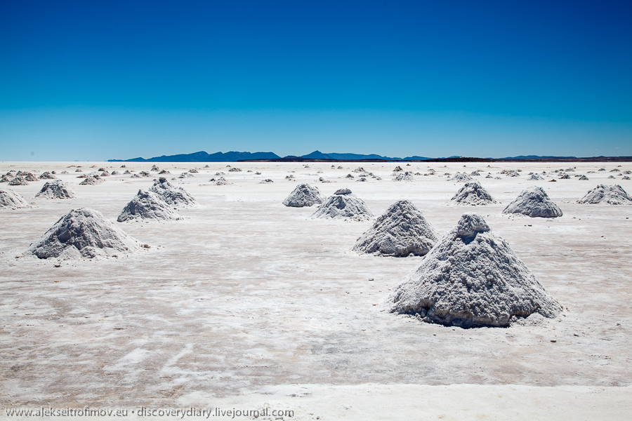
Continue reading Salar de Uyuni

In and out of Cerro Rico

Potosí is a place quite out of the ordinary. First, it’s the highest city in the world at 4090 metres. Second, this city was once the largest in all of the Americas, and even exceeded London and Paris at some point. The reason for all were the famous Potosí silver mines located inside Cerro Rico – the Rich Mountain. Enormous amounts of silver were mined there and served as the main source of income for the Spanish empire for several centuries. The silver was carried on the backs of mules to Lima and from there the imperial galleons took it over the Atlantic to Spain. The arrival or delay of these galleons were decisive for empire’s finances. The numerous wars led by the empire were financed by Potosí silver. The characteristically conical Cerro Rico looks over Potosí. They say that over the centuries of mining it has gradually lost several hundred metres in altitude.

Continue reading In and out of Cerro Rico

Sucre

My next stop was Sucre, the constitutional capital. Lonely Planet promises that Sucre will be Bolivia’s most pleasant city and the visitor will want to stay there much longer than initially foreseen. That prediction turned out perfectly accurate! Sucre is full of students, calmness and sun, and it was indeed very pleasant to spend a couple of days there.

The view of San Felipe de Neri convent. It is still used as a school. The visitors enter via the main school entrance and can see the still-functioning classrooms inside the historical building.


Continue reading Sucre